Skip to product information
1 of 1

Bois D'Arc Lake Fishing Hotspots

Bois D'Arc Lake Fishing Hotspots

Regular price $110.00 USD
Regular price $137.50 USD Sale price $110.00 USD
Sale Sold out
Online Download or Physical SD Card
Fishfinder

The only map of Bois D'Arc. 

This SD card will plug into your fishfinder and upload 3 trails and 120 waypoints. The GPS trails will show on your chart the EXACT locations of creek channels, turns, oxbows, and roadbeds. The waypoints will display house foundations, pond dams, TPWD fish attractors, TPWD timber piles, TPWD gravel beds, and boat ramps. 

This will show the creek channels and turns much better than mapping cards like Navionics, C MAP, and Lakemaster so you can graph out deep or fish up shallow and know you're where the bait and fish are! 

Available for Humminbird and Lowrance fishfinders as an online download or as a physical SD card mailed to your door.

For online downloads, have an SD card ready to go. Upon checkout you will be sent the files for download! Learn more about how to upload.

This product is not intended for navigational purposes when driving on plane. This product is only displaying the creek channels, pond dams, and house foundations for fishing and graphing purposes. 

View full details

Customer Reviews

Based on 4 reviews
100%
(4)
0%
(0)
0%
(0)
0%
(0)
0%
(0)
E
Eric Medders
Lots of great brush likes

I am very happy with the waypoints that I received for Bois d arc lake. After a quick trip out there we found the brush piles right where they were marked.

T
Tuya Burton
Lake Bois D’Arc Texas

Really enjoying it!

B
Brandon Glass
This is a Great Lake product

This is a life saver for people that like to fish & catch fish without having to drive all over the lake to find the fishing holes

B
Barney Lehnherr
Great Detail

The first new lake in TX in years. I've been studying my map. Fishing Map Card has a lot of great detail. I can't wait to put all this information to use. Hope to fish Bois d'Arc later this month and I'll be able to hit the water with a plan.

Frequently Asked Questions

What is the point of these products? Why should I use them?

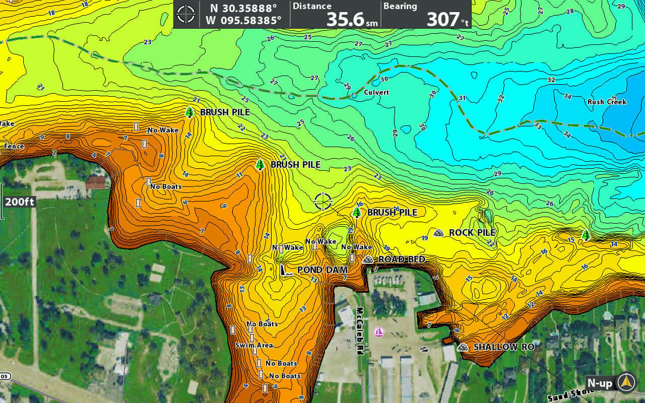
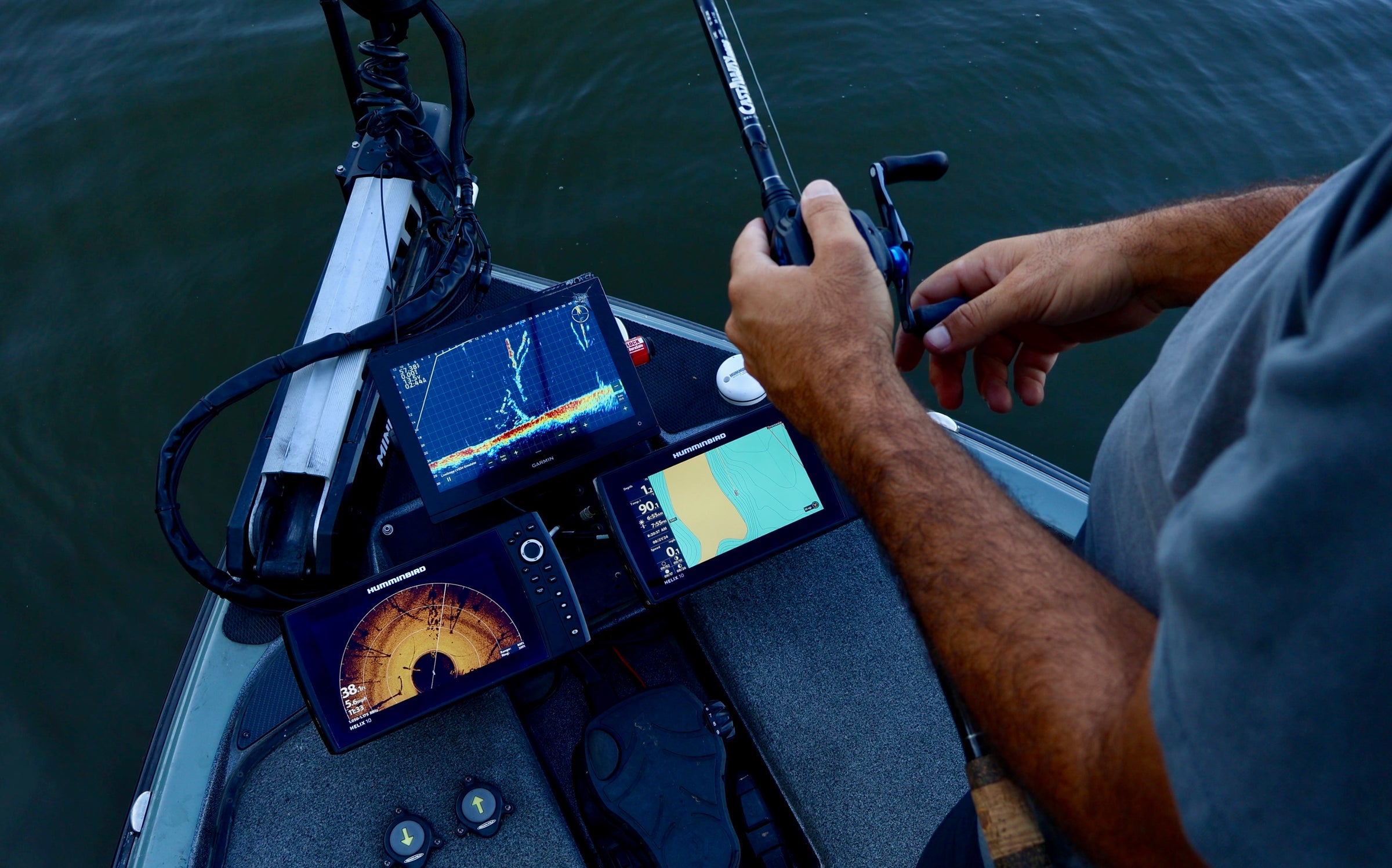
These are removable micro SD cards and SD card adapters that contain fishing hotspots. Each fishfinder comes with micro SD or full size SD card slot to install waypoints, retrieve screenshots, update software, or install upgraded contour maps.

These SD cards are mainly filled with fishing hotspots and creek channels to help you narrow down where the fish are quicker to help you run a pattern of how to catch fish all over the lake.

These are designed to give the newer anglers, weekend warriors, or traveling tournament fisherman the best odds at doing well when they can't spend all of their time idling around and looking for structure. Take the hard work of guides to be able to narrow down where high percentage spots and populations of fish are to make your days on the water more enjoyable.

Can I upgrade my purchase later on?

Definitely! If you purchase a silver or gold level SD card and want to upgrade it, send us an email with your name, order number, or contact email at sales@fishingmapcards.com. Let us know which product you'd like to upgrade to and we can send a new invoice for the cost of the difference!

How do you mark these spots or channels?

Unlike other freshwater mapping companies, we actually travel to these lakes and put the time in to idle the lake and graph high percentage spots. Using guide and professional tournament knowledge along with time on the body of water, these fishing hotspot maps are created where we actually fish on the water.

The creek channel maps are created using aerial imagery to trace creek channels and find pond dams and then are confirmed on the water.

Should I get a physical SD card or do an online download?

This is entirely up to you. For online downloads, an email is sent to you immediately upon checkout containing the files you need to upload. If you have experience downloading waypoints this is an easy process. If you have trouble downloading or installing, check out out How to Upload.

If you are unsure of how to download these products or don't have a micro SD or full size SD card available, we suggest getting a physical card. We install each product on to our own fishfinders before we send them to you to confirm the SD cards and products are up to standard.

How do I upload to my fishfinder/chartplotter?

Check out our How to Upload page!

What if I want the same product for multiple fishfinder brands? Do I get a discount?

Yes! We have it automatically apply a 75% discount to your 2nd or 3rd fishfinder brand.

If you have already made one purchase and want to make another please email us at sales@fishingmapcards.com.

What if I want multiple lakes on the same physical SD card? Do I only get one SD card?

Yes! You get one card. A discount is automatically applied during checkout.

Please add all products in the form of physical SD cards. Your cart will automatically update to decrease the price to reflect only one SD card being sent. If not otherwise noted, all files will be combined into one for Humminbird files.

Do I get a discount if I get multiple lakes?

Yes! You will get a discount automatically applied if you get multiple products. You also get a discount if you order multiple SD cards.

Can I stack discounts?

If your order qualifies for multiple discounts, only the largest discount will apply.

What size SD card do I need for online downloads?

For Lowrance -

We recommend micro SD/SD cards between 2-32gb. For more information on your specific unit, check out SD card sizing for Lowrance.

For Humminbird -

We recommend any microSD/SD card up to 32gb as recommended by Humminbird.

For Garmin -

As recommended by Garmin, any card up to 32gb between class 4 and class 10 will work with their chart plotters.

What size SD cards would I receive in the mail?

Depending on your fishfinder, we send out either 2gb or 8gb cards with adapters.

How do you ship these cards?

Each card is sent in a bubble mailer with instructions on how to upload to your specific fishfinder.

These packages are shipped out using either USPS or UPS. At checkout you will be prompted with either service and shown delivery dates for different options.

We try our best to get these products out as quickly as we can. We ensure each products SD card and file will upload to our own fishfinders before we send them out.

What format are the files?

Lowrance files are .gpx files. Some units like the Elites may require .usr files.

Humminbird files are .ht and .hwr files.

Garmin files are .gpx files.

Why aren't some of your products compatible with my Garmin?

Garmin uses a different format for their tracks and trails that does not work with our software. Tracks like creek channels that we mark are a combination of 100's of smaller tracks combined into one. Garmin won't show these trails correctly which reflects some products having a less expensive cost for Garmin products or not even having Garmin as an option.

Contact form